Another school assignment. My teacher was particularly impressed with this and said ‘it is written like a university dissertation’. I am very happy with this essay but of course it is not perfect.
In 1912 Alfred Wegner, a German geophysicist and meteorologist, proposed that the outer layer, the lithosphere, of the Earth is divided into several tectonic plates which ‘float’ on the mantle or asthenosphere and move in different directions driven by convection currents and that this movement causes the plates to collide in some areas and separate in others to create new crust. This theory arose from criticism of Wegner’s continental drift theory for which he had previously provided no driving mechanism for. There are multiple sources of evidence for this theory of plate tectonics with varying plausibility, such as the pattern of volcanic eruptions and earthquakes, seismic profiling, ophiolite sequences, hotspots, age measurements of the sea floor, palaeomagnetic stripes, many landform features and all of the continental drift theory evidence, which I will proceed assess.
Firstly, the idea that the Earth’s crust is divided into seven large plates as well as some other smaller plates can be evidenced by the pattern of volcanic eruptions and earthquakes. These events seem to be focused in specific areas of the world, for example the Pacific ring of fire, a large ring in the Pacific Ocean where a significantly large number of earthquakes and volcanic eruptions occur; approximately 90% of earthquakes and 81% of the largest earthquakes occur here. The ring of fire is supposedly the result of the boundaries between the Pacific plate and the Nazca, Cocos, North American, Eurasian, Philippine and Indo-Australian plates. A distribution map of earthquakes and volcanoes immediately highlights the proposed boundaries between plates (figure 1). The theory is that the pressure build up and sudden release as a result of the plates crushing into each other or magma forcing its way up from the asthenosphere is what causes earthquakes and volcanoes occur. This concept is well evidenced and difficult to deny as the distribution map clearly displays the outlines of plates and there is no significant alternative explanation for why this pattern of distribution exists. Although, there are anomalies, such as earthquakes occurring in the centre of a proposed plate, but these can be explained by other theories, which will be mentioned.

figure 1: world distribution map of earthquakes 1960-2000
Secondly, the philosophy that the plates are floating on the mantle has much supporting evidence also. The structure of the Earth is proposed to be from the centre outwards inner core, outer core, mantle, upper mantel or asthenosphere and lithosphere. Seismic profiling can support this to a certain extent. P-waves and S-waves produced by earthquakes or artificially travel at different velocities depending on the medium of substance which they are travelling through. These velocities can be predicted by the following equation with μ representing elastic moduli and ρ representing density.

Distinct changes in the velocity of the p- and s- waves mark boundaries between the three main divisions of the earth’s interior: crust, mantle and core (figure 2). At the crust mantle boundary, the Mohorovičić discontinuity, the waves speed up because the elastic moduli increases and the density decrease. This suggests there are layers of the Earth’s interior, that the crust is distinct from the mantle and that it does lie on top of the mantle. However, it is claimed that the crust is simply a cooled outer portion of the mantle but still the same substance. Similar to how water and ice are the same substance but have different physical properties; therefore, the crust cannot be floating on the mantle as it is part of the mantle. Also, this would suggest that the solid crust would be cooler, solid and so denser than the mantle, so should sink. Nonetheless, the seismic profiling suggests that the properties of the mantle and the crust are dissimilar enough to label them different entities with the crust. What is more, shield volcanoes also suggest that the plates float on the mantle to a certain degree as the mantle can be seen to be rising to the surface as magma then lava at constructive plate margins. Nevertheless, it cannot be confirmed or denied that the lava came from the mantle, so this evidence is less substantial. Additionally, ophiolite sequences provide evidence for the contents of the mantle. People have not yet been able to drill to the mantle to study it but ophiolite sequences, small segments of ocean crust and mantle tectonically exposed, showing deep-sea sediment, basalt, gabbro and peridotite (mantle) reveal the contents of the crust and the mantle and can explain how they are different. This insinuates that the crust and mantle are different and that the crust sits on top of the mantle again. However, ophiolites are a distorted representation of the mantle and crust as they have experienced higher pressures and lower temperature than normal and so could be structurally and chemically different from the actual crust and mantle. Subsequently, this evidence is also somewhat unreliable. Overall, this theory of plates floating on the mantle is slightly less persuasive than the previous concept.
 Figure 2: variation in p- and s-wave velocities at different depths
Furthermore, the hypothesis that the plates are moving in different directions can be reinforced by hotspots, age measurements of the seafloor, palaeomagnetism and the continental drift theory evidence. To begin, hotspots seem to create chains of islands, such as the Hawaiian archipelago in the centre of the pacific plate. The fact that the hot spot creates a chain of islands and not just one large island in one place infers that either the hotpot is moving or that the plate is moving over the hotspot allowing the mantle plume to pierce the crust in multiple places. It is generally agreed that hot spots are fixed in position relative to the faster moving overhead plates as there is no endorsing evidence that the hotspots do not move but there is other evidence that the plates do move. Another theory could be that there are multiple hotspots; however, carbon-14 dating has proven that the islands furthest away from the proposed main hotspot are oldest and the closer to the hotspot the younger the rocks become, so it is unlikely that each island is being formed simultaneously by multiple hotspots. More convincingly, the proof of age measurements of the sea floor showing that crust spreads away from mid ocean ridges also demonstrations that the plates are moving. For instance, aging of the Atlantic Ocean via radioactive decay shows that the youngest rocks are found at the constructive plate boundary (the mid-Atlantic ridge) in the centre of the ocean and the oldest rocks are found at the destructive plate boundaries on the outskirts of the basin. This implies that new crust is being created at the central plate boundary and the plates then slowly move away from the boundary because the rocks get progressively older the further away from the ridge (figure 3). There are no other justifications for this progressive rock age so this evidence is very significant and dependable. Similarly, palaeomagnetic stripes being mirrored either side of the mid-Atlantic ridge suggests that the plates are moving. Occasionally, the currents in the liquid core of the Earth, which create the Earth’s magnetic field, reverse – geomagnetic reversal. During World War II, ships used magnetometers to locate submarines. As the ships travelled across the Atlantic they found bands of alternating strong and weak magnetism in the rocks of the seafloor (figure 4). Later it was realised that the stripes are a result of rocks solidifying at the crust surface with the magnetite crystals within permanently locked into alignment with Earth’s magnetic field of the time of solidification. High-intensity zones correspond to seafloor formed during a period of magnetic polarity the same as it currently is and low intensity zones correspond to seafloor formed during a period of reversed magnetic polarity. Crucially, the magnetic patterns are parallel to the mid-ocean ridge and symmetrical on both sides suggesting that new crust is created at the mid-ocean ridge, solidifies with the magnetite crystals aligned with the current magnetic field of the Earth and then moves away. When the polarity switches the crust solidifying at the ridge will have a different polarity to the rock created previously and bands of differing polarity are the result. This evidence is seemingly undeniable and a very strong. What is more, another source of evidence that the plates are moving is the evidence for continental drift. The fit of the continental shelves of the West coast of Africa and the East coast of South America suggest they were once joined; therefore, the plates must have moved apart since then. Also, fossils of ancient plants and animals are found on continents separated by vast oceans. For instance, Mesosaurus and Glossopteris fossils were found in areas of Africa and South America which would have been joined before they supposedly drifted apart (figure 5). Another explanation for this is that there was once an ice bridge between the two continents; however, Mesosaurus is a freshwater reptile, so would not walk on the land bridge and would not be able to swim the entirety of the salty ocean to the next continent. Glossopteris seeds, however, could have been transported by land dwelling animals across the ice bridge, but this is unlikely and it is more plausible that the land was once close together and has since moved apart in plates. Likewise, rock type and structural similarities across continents which are proposed to have once been one land mass highlight plate movement (figure 6). For illustration, the Appalachian Mountains in North America, Caledonian Mountains in Scandinavia and mountains in Britain all have similar ages, structure and rock type suggesting they were once a single mountain range. Correspondingly, these mountain ranges align if the continents are drawn together in the suggested original landform, Pangea. Also, paleoclimatic evidence supports the theory of plate movement. Evidence of ancient glaciers is found in areas with climate to warm to ever be covered by ice sheets in the form of glacial erosional features such as scratched bedrock and U-shaped valleys in Southern Africa, for example (figure 6). This suggests that the continents we know today were not always in their current positions but are moving around the Earth’s surface. This evidence is less convincing for me as it is difficult to determine if the planet was ever cold enough for ice to cover Africa in its current position.

 Figure 3: Age map of the Atlantic Ocean floor
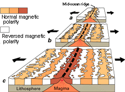 Figure 4: the formation of palaeomagnetic stripes
 Figure 5: fossils spanning continents
  Figure 6: evidence of past glaciers & rock structures across continents
In addition, it is proposed that plate movement is driven by convention currents in the mantle, but there is little confidence-instilling evidence for this. Convection currents can be clearly demonstrated in water using dye or in air using smoke, but it impossible to witness the convection currents in the mantle. It is theorised that heat from radioactive decay of substances in the Earth’s core, such as potassium, produces the heat which causes the molten rock at the bottom of the mantle to heat up, become less dense and rise. Once the molten rock approaches the crust it cools, becomes denser and can sink down towards the core before being heated again and repeating the process. This creates cycles of convection which are proposed to push and pull the tectonic plates around because of friction with the lithosphere. The hotspots around the Earth provide evidence that some areas of the mantle are warmer than others and could have a constant mantle plume. However, when simple basin models were used to replicate convection in the mantle the convection cycles were dynamic and plumes never remained in the same place for long, which would suggest that the convection theory is wrong. Nonetheless, the simple basin model does not account for the spherical shape of the Earth or the Coriolis and centrifugal forces, which will affect the convection currents. Largely, this theory has many flaws and there are other, perhaps more convincing, mechanisms of plate movement, such as slab pull and ridge push. Slab pull would have originally been set in motion by convection currents pushing to plates together and causing the denser one to sink under the other. This subduction will keep sinking and pull the rest of the plate with it even if the convection currents are no longer pushing the plates that way. This explains why the simple basin model exhibited dynamic convection cycles. Also, ridge push would also have been started by convection currents. A mantle plume would have pushed one portion of crust upwards and created rifts and two plates from one. The elevated lithosphere now has gravitational potential energy and the crust either side of the rifts will move down the slope to achieve a lower energy, moving away from the bulge. Also, rising magma will force its way to the rifts and add further pressure to push the plates apart. These theories are more probable as they coincide with the idea that convection currents constantly change; still, they cannot be verified absolutely.
As well as this, evidence for the idea that in some places plates collide is more tangible. Landforms such as Fold Mountains and oceanic trenches indicate that one plate is being subducted under another. Where an area of sea separates two plates, e.g. the hypothesised Tethys Sea between India and Asia, sediments settle on the sea floor in depressions called geosynclines and are compressed by ocean pressures into layered sedimentary rocks the plates move towards each other, the layers of sedimentary rock on the sea floor become crumpled and folded into anticlines and synclines. Eventually, the sedimentary rock appears above sea level as the continental plates join and the last of the oceanic plate is subducted producing a range of Fold Mountains. There are no other theories about how such specific rock structures could have formed other than this collision theory, so Fold Mountains are a significant evidence source for collision boundaries. Trenches are formed by the subduction of a tectonic plate. As the denser plate is pushed beneath the lighter plate, the lithosphere bends to form a steep, V-shaped depression in the seafloor. Trenches can be seen in bathymetric maps and are fairly noteworthy evidence for plate collision as other reasons for trench formation are scarce. Another landform, a thrust fault, shows how compressional forces have affected the land. As pressure builds up as plates collide the rocks are compressed and can shift suddenly to relieve the pressure. These often occur at collision plate boundaries and can be observed by aging the rock layers as the rocks which are shifted upwards will be older than the rocks next to them which have not been shifted (figure 7) and the fossils within the rock layers will be inconsistent. Evidence that one plate subducts beneath another at destructive plate boundaries is in earthquake depth and the Benioff zone. Earthquakes occur at plate boundaries as shown by figure 1, at subduction plate boundaries the focus of an earthquake can be very deep and they often occur within a downwards dipping planar zone (figure 8). This evidence can be proven by seismology to determine exact focus points and heavily insinuates that one plate is being forced down under another and eventually melts when the earthquakes no longer occur at that depth. The idea of pressure build up also supports the evidence of composite cone volcanoes forming at subduction plate boundaries as the pressure build up and increase in magma from the subducting plate forces the magma to rise through the crust and emerge in an eruption creating a stratovolcano over many years from cooled lava accumulation. This theory is plausible but there are other explanations for why a volcano has formed here; it could be because there is excess heat from the friction between the subducting plate and the continental plate melting the crust, but this still supports the idea that plates are colliding.
 Figure 7: thrust fault formation
 Figure 8: the Benioff zone
On the other hand, in other places the plates separate and create new oceanic crust. This theory also has evidence to underpin it. For instance, rifts in the Earth’s crust such as the Afar rift and the East African rift valley (a result of the African plate pulling apart), suggest the crust is being stretched and is splitting to relieve pressure and cover the new distance. If the plates are being pulled apart then there is opportunity for the asthenosphere to rise up because it is hot and will expand if possible through a gap. Once it reaches the surface it will cool and condense into solid rock forming new crust. Evidence for this is the same as seafloor spreading with palaeomagnetism and the progressive aging of rock from the mid-Atlantic ridge to the edges of the Atlantic basin. However, the east African rift valley is not at a constructive plate margin, there are not two plates separating, it seems one plate it splitting apart. Another proposed theory for the rifts here is a hotspot under this area of continental crust creating a bulge in the lithosphere and causing the brittle crust to fracture in the same way glaciers form crevasses when curving over a rock lip. Additionally, at Iceland fissure volcanoes can be observed first hand. The thin but long volcanoes spill up lava through rifts in the crust and infer that the plates are pulling apart and new crust is being created as magma rises to the surface to cool. This evidence is solid as it can be observed with the human eye and nothing else has been theorised to cause the rifts.
To conclude, the weakest evidence for the plate tectonic theory seems to be the convection currents in the mantle as it cannot be observed first hand and any models cannot be close enough to the scale and shape of the mantle to make a definite conclusion. The most convincing proof is most likely that the plates are moving in different directions as not only is it supported by all of the evidence for continental drift but also by the progressive age of rocks and palaeomagnetism provides extremely credible evidence as the rock bands reflect each other exactly, to which there can be no other explanation. Consequently, this means that in some places plates have to be colliding and in some places plates have to be separating, so the evidence for these philosophies is more believable. The idea that the plates float on the mantle is less easy to prove as there is little discrepancy between the mantle and the crust. Even the fact that the lithosphere is a layer made of both crust and mantle shows that the two are almost indistinguishable, so to claim that the crust floats on the mantle is unwise.
